Mount Varnoundas (Peristeri Massif)
- Forest, Hiking-Trekking, Mountains
- Geo Area: Macedonia

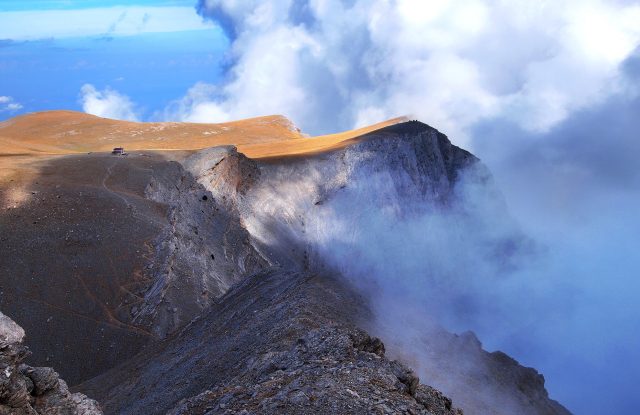
Mount Varnoundas, also called Varnous or Peristeri, rises between the town of Florina and the Prespa Lakes, in the north-west of Macedonia. Its main ridge is the border with North Macedonia, and its highest Greek peak, Despotiko, reaches 2,334 metres. The mountain is made of granite, with forests of beech and oak below and open meadows above. Bears and wolves live in these forests. Visitors come here to walk. Easy marked walks start in the village of Agios Germanos, on the Prespa side, and long routes climb from there to the high peaks. Other routes start at the pass of Vigla, near the village of Pisoderi, where there is also a ski centre. The western slopes are part of the Prespa National Park.
Geography
Mount Varnoundas, also called Varnous or Peristeri, stands in the north-west of the regional unit of Florina, between the town of Florina and the Prespa Lakes. It is the Greek part of a larger mountain. The same mountain continues north into North Macedonia, where it is called Baba and reaches 2,601 metres at the peak of Pelister. The highest point on the Greek side is Despotiko, at 2,334 metres, and it stands on the border. This peak is also known as Kitsevo.
Several other peaks rise above 2,100 metres, among them Bela Voda and Kirko. The rock is granite, and the summits are bare and rounded. In the south, the pass of Vigla, near the village of Pisoderi, separates Varnoundas from Mount Verno. Streams from the western slopes run down to the Prespa Lakes, and the largest of them passes the village of Agios Germanos. The western slopes belong to the Prespa National Park.


Activities
People come to Varnoundas to walk. Short marked walks start in the village of Agios Germanos, on the western side. One follows the stream down to the village of Lemos and takes up to two hours. Another goes round Agios Germanos itself in about an hour.
The routes to the high peaks are long and are for walkers with experience. A circular route of about 27 kilometres climbs from Agios Germanos to the peak of Kirko, at 2,155 metres, and has a wide view over the Prespa Lakes. Another route, about 17 kilometres long, goes to the peak of Bela Voda and has no marks. The path to Despotiko climbs open slopes with no shelter in bad weather.
The E6 European long-distance path crosses the mountain from the ski centre at the pass of Vigla to Agios Germanos, over a ridge above 2,100 metres. Walkers report that it is not maintained and that the path is hard to find in places.


Villages & Inland
Two villages are the usual starting points for the mountain.
Agios Germanos
The village stands at about 1,040 metres on the western side, seven kilometres from the shore of the Prespa Lakes. Its houses are built of stone, with wooden details, and many date from before the Second World War. The church of Agios Germanos was built in the 11th century and has wall paintings from three periods. A restored watermill received a Europa Nostra award in 2016. The village also has an information centre for the national park.
Pisoderi
Pisoderi stands at about 1,420 metres on the southern side, next to the pass of Vigla, and beech forest surrounds it. The village has houses in the traditional style of Macedonia, the church of Agia Paraskevi and an old school building from the early 1900s. The monastery of Agia Triada stands north-west of the village.


Nature & Outdoors
Forests of oak and beech cover the slopes of Varnoundas, with fir and birch in some places. The beech forest is thick around the village of Pisoderi, on the southern side. Above the forest there are mountain meadows with many wild flowers, and crocuses flower there in late spring.
Large animals live on the mountain: brown bears and wolves, roe deer and wild boar. Chamois are also reported on the high ground. Seven kinds of woodpecker live in the forests, golden eagles are among the birds of prey, and eagle owls nest on the rocks. The western slopes are inside the Prespa National Park. The area around the Prespa Lakes was first protected in 1974.

Practical information
Getting there
The routes start on two sides of the mountain: at the village of Agios Germanos and at the pass of Vigla. Both are reached by the road that runs west from the town of Florina to the Prespa Lakes. The pass is about 20 kilometres from Florina, next to the village of Pisoderi and its ski centre. Agios Germanos is about 48 kilometres from Florina, on the Prespa side. The Prespa basin is about 200 kilometres from Thessaloniki.
Good to know
The routes to the high peaks have few marks or none, and the E6 path is not maintained. Carry a map or a GPS track, and do not go alone if you do not know the mountain. The main ridge is the border with North Macedonia. A mountain refuge stands on the circular route above the village of Agios Germanos. Ask at the national park information centre in the village about the refuge and the state of the paths before you plan a night on the mountain.
When to go
Snow stays on the high ground into April. Winters here are long, with heavy snowfall, so the long routes are for late spring, summer and early autumn. In autumn, fog is common on the ridge. The short walks around the village of Agios Germanos are at about 1,000 metres and are possible for more of the year. In winter the high peaks are for mountaineers with winter equipment and experience.
Mount Varnoundas (Peristeri Massif)— been there?Tell others what you saw.
A photo and two lines are enough.